... a very cool 17 mile stretch of highway linking the low Mojave Desert (via Rt. 95) with the high country of the Spring Mountains and Mt. Charleston, Nevada - an approximate 10,000ft elevation gradient from the desert floor to the Mt. Charleston summit...
(internet image)
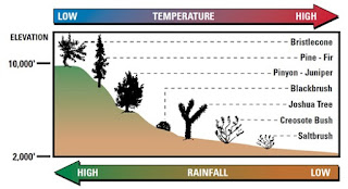
... the route bi-sects all six climate zones of the Mojave Desert - the progressive cooler temperatures as one ascends in elevation throughout the climate zones in turn produce life zones where different species of plant and wildlife exist...
(internet image)
... from lowest elevation to the highest, the six life zones are the Lower Sonoran, Upper Sonoran, Transition, Canadian, Hudsonian (sub-alpine) and Arctic (alpine)...
... viewing west from around EL7,000ft toward the Spring Mountains...
... the change in habitat is similar to traveling from the Desert Southwest to the Canadian Arctic...
... Nevada 156 viewing east toward the low desert from around EL6,000ft...
... that's about as technical as we get - visit local "desert rat/mountain man" (and PhD Ecology) Jim Boone's excellent website,
'BirdandHike.com', to get more information than you can mentally process on this area and the Desert Southwest in general...
... when out visiting 'Strongman Matt' we like to spend at least one day out exploring some new (to us) area of this fantastic wilderness...
... some limestone cliffs...
... Juniper berries...
... Barrel Cactus...
... pine and juniper canyon...
... this past visit we did a bit of "hiking about" between EL4000ft and EL6,000ft, or the Upper Sonoran Zone, and it's diverse mixture of desert shrubs, cacti and Joshua Trees...
... and abundant wildlife such as Antelope Squirrels and Black Tailed Jackrabbits (seen here - look close - he's well camouflaged) - had tallied twenty-five jackrabbit sightings in about a half hour of hiking before we quit counting - managed an acceptable photo of two...

... lots of diverse bird species - saw a few large ravens (above) and a few hawks which themselves are particularly cool to view when cruising low and on the hunt... parked just up-road from a relatively recent roadkill jackrabbit (the day of this image) that we noticed had one large raven and one hawk jockeying for position on the carcass - the hawk actually landed on the stem of a very close Joshua Tree providing a very cool photo opportunity - but after a minute or more of fumbling with changing to a longer camera lens he was gone... couldn't get either bird to circle any closer after that - tossed the jackrabbit off of the pavement surface and into the adjacent brush, hoping to return a bit later after they'd forgotten my presence - came back in about a half hour and the carcass and both birds were gone...
... the entire territory is pockmarked with small wildlife dens and burrows...
... figured we hike over to these distant ridges - about four miles round trip...
... which involved traversing several wide 'arroyos' (or wash, gulch, dry drainage, gully, draw - take your pick)... surprising how rugged the landscape becomes when ya' venture off the pavement - not as flat a desert as it appears...
... was out the previous evening and stumbled across these wild Burros...
... thought we'd have some fun and spend some time trackin' them today...
... not hard, just follow their well worn trails...
... and turds...
... but their pretty cagey - will just circle right back around unseen if you're not smart about it... was a really windy and chilly day, so we hiked across desert to put the wind in our face and circled right back around playing their game - note the obvious wildlife trail in this image...
... Matt tracking along a selected game trail...
... just after stumbling across this large Elk antler shed...
... was a pretty nice one - was a bit surprised to discover it at this lower elevation as the Elk are said to inhabit the higher elevated forest zones... Mt Charleston is the only known habitat of Rocky Mountain Elk in the region...
... after a bit of effort, finally came across this small herd of four Burros - pretty cool...
... they'll let ya' get to maybe within 200 feet of 'em then book - but maintain that buffer...
... a final image we kind of like with this black haired guy (or gal) against the large desert backdrop...