Sunday, January 27, 2013

Tri-hill-ogy (Mountain Biking Part 6)

Might as well submit one final mountain biking post - a good training ride.

Called the Tri-hill-ogy. Climbs three good hills (get it). Total elevation gain around 2,000ft (combined). Total length between 6-7 miles. Time around 1.5 hours. Start at Betty Knox parking lot - ride to the top of Lambie Rocks hill, descend back down to the intersection and climb to the top of Rob's Knobs hill, descend back down and follow the main Game Lands road between the 'Knobs' and 'Lost Crag' to the top of the long hill - descend back down to the parking lot. If you want a real workout, descend back to the 'Betty Knox' parking lot after each (did it probably five times - pretty tough). Would like to try it totin' the cart and some sandbags - didn't have it back then - glad I'm now too old for that.

The map:


The 'Lambie Rock' route is approximated - didn't plug in the co-ordinates - can't miss it though - is an obvious intersection just past the 'Rob's Knobs' trail - follow to the left.

Don't mess with Ig....

03/02: The saga continues - was on the final approach to home from work yesterday afternoon and approaching the "Nelson" home - looks like a lot of police activity up ahead - flashing lights and a few officers standing in the road. Slow down as I drive by. Spot two marked and one unmarked State Police cruisers in the parking lot across from the house, several cops milling about and, hey... wait a minute... there's "Ozzie and Harriet" - both in handcuffs. Waved and gave 'em both a few toots on the horn - a model couple, those two. Feel bad for the brothers, though - they're OK in my book    

Had to revise this post (01/29) - the 'boys' returned last night to offer their apologies for throwing the snowballs and brought a few bags of 'treats' for the cat - I was a little suspicous - checked the bags carefully, looked OK with no tampering - he ate half a bag and is still standin' - so no problem as far as I'm concerned. Good guys, I guess. Said that the guy I floored was their mom's boyfriend. Is wasted most of the time and they don't like 'em - told 'em that makes three of us.

Original Post:  ...he's got backup - got a call from Tim earlier today - "we're goin' climbing at the 'Gun Club" - "I'll see you there!" Drove out around noon - Tim and some new guys are at it. Hung around and scoped the action and snapped some photos. Good climbers, as usual. Stink-man along for the ride - he's up there in years - I know his limit at his "old age" - took him home after a few hours, intending to return. Round the bend to the 'homestead' - What!!?? - here comes Ig runnin' for his life - two 'young punks' firing snowballs at him. Gun it and park - look at the house - three tossed snowballs stuck to the storm door glass - jumped out and grabbed the nearest 'tosser' by the hood (at least fifteen years old). Face planted him in the snow and held him for at least a minute - the other guy ran for the hills - finally let 'em up - cryin' like a baby - "I'm tellin' my Mom!! (used to tell your dad in the 'old days'). Some time later later I hear a "hootchie-muffler" - knock on the door - I ain't talkin' - push the door open in some creeps face and double arm bar 'em in the chest - goes backward asshole over elbow into the gutter - one of the local crack-heads from a block over, just as I suspected - "You're goin' to jail!!" he shouts - jumps back into the "hootchie - car" - creepy bleach blond at the wheel, swearin' like no tomorrow - they go gunnin' up the road - I step in the door - here they come again - "Queer!!!" shouts "hootchie-mom".....

...ya' gotta' love it.....

Anyway - a good day overall.....


One good thing about ice climbing - ya' never know what to expect from year to year.....


....ditto...


...Internet Connection.....


....Tim got a pretty cool beard happenin'...


...Stink on watch.....


....Ig - safe and sound.......

By the way - was waiting for the 'cops' to show up as forewarned - never happened......or else would have been back out........


Sunday, January 20, 2013

Cow Rock Loop (Mountain Biking Part 5)

Recently got 'Backcountry' up and running. Not the best transfer - original master is on Beta tape - no longer have a player - transferred to disc from a back-up S-VHS tape originally copied from the master tape edited from a Beta tape work print copied from the original processed 16mm color negative film - probably a fourth of fifth generation duplicate. Some quality loss with each tape transfer - exhibits some color "bleeding" and loss of resolution quality at full screen. Also, the tapes are up there in years.

One last short bike route - The 'Cow Rock Loop' - around six or seven miles in length - 900ft elevation gain - 1.5 to 2 hours round trip. Begin several hundred feet past the end of the blacktop and old quarry along 'Cow Rock Road' near the large 'frog pond' on the left. Park here. Continue upgrade on bike along the unimproved road for 3-4 miles (staying right at the intersection located about 1/3 of the way - if you start descending a steep hill, you're off route). At the third major intersection, follow left, continuing upgrade for several hundred feet to merge with a wide State Game Lands (SGL) Road,  eventually emerging several hundred feet to the northwest of 'Elk Rock'. Follow left (if you don't hang out at 'Elk Rock' for a spell) over rolling terrain for about 1/2 mile to a 'T' intersection. Two trails 'Y' to the right - take the left trail to the north. This is the single track as described toward the end of the 'Big Loop'. Enjoy the scenic overlooks and steep downhill flanking the Yough River gorge. You'll eventually round a large right facing 'horseshoe bend', then a short steep uphill, then continue downgrade to an eventual large timbered clearing. Stay right past the clearing, continuing along the single track thru the woods (if you take the wide road leaving the clearing, you will travel a long uphill to return to the first intersection as described at 1/3 mile from the start - you can go this way as well, eventually reversing your path). Follow the rolling single track - eventually climbing a short, steep hill to a nice boulder field - continuing past the large boulders the trail descends for about a mile (fun rolling and winding downhill). You'll eventually arrive at an intersection with a trail veering left - follow this trail back to the 'frog pond' and vehicle (if you miss this trail - you'll shortly arrive at a 'T' intersection - turn left here as well and follow back to the 'trailhead').

The map:


Recap: These are a few of the endless riding opportunities within the south end of 'Chestnut Ridge - just wanted to highlight a few of the best. Much more - from 'Quebec Run' to 'Ohiopyle' to the 'Dunbar Mountains' to 'White' to 'Linn Run' and everything in between. In these parts, pretty much any dirt road or trail exiting the 'hard top' or 'beaten path' is a possibility.

The routes as plotted on all the mapping were located as identified on the USGS topographic map layer where available, supplemented by GPS 'waypoints' measured 'on route'. 'Gray areas' were plotted from memory - probably accurate to within 100ft, at worst - no guarantee.

Some final photos:


Upper: Matt & Howie at a steep section of the 'Foundation Loop' in Casparis, probably around '94
Bottom: Matt - his last ride in these great hills - Cow Rock Loop - probably '04


 Howie at the Yough River Crossing of the 'Big Loop' 


Above the Yough Gorge Crag


'Sandy Flats Loop' in winter


Most always had a hairy friend tagging along 


Spring head along the YRT


Abandoned railroad trestle at mouth of 'Indian Creek' - not a good place to lose your balance


Overlooking the west flank of the Yough River gorge - viewing south. The railroad trestle at 'Indian Creek' is just north of photo center, at the right hand river bend - this is also the spot of the river crossing. Note the white helicopter just left of photo center


Sunday, January 13, 2013

Sandy Flats Loop (Mountain Biking Part 4)

Total length around 6 miles. Total elevation gain slightly over 1100ft (in three miles). Trip time around 1.5 hours (however, has been done in just around 1 hour during several "speed attempts").

Not every trail is a four to eight hour "expedition". Much shorter, but just as rugged, trips are possible by linking to the many "alternate" trails as indicated on the provided mapping. The 'Sandy Flats Loop' is  one such. Start at the bottom of 'Casparis Hill' and follow the unimproved road uphill and continue along more gradual ascent to reach 'Foleys Pond'. Pass the pond and continue up steeper terrain (used to be a technical climb over several rock ledges - however, they graded this section in the past few years to facilitate truck access for timbering) to a sharp left shortly after the top of the hill. The trail narrows at this point. Continue on past several large puddles and a few wellheads for about a mile to a large intersection linking Trump Hollow, Tates Hollow and the top of the ridge. Turn left (west) and follow back (quickly, if you prefer) along the ridge, traveling thru 'Sandy Flats' and open terrain. Past the 'Flats', the terrain narrows, traveling back thru the woods for a way before descending back down the ridge. Shortly after you begin a loose, gravelly descent, watch for a sharp left off the main trail, which continues straight. Take the left, and continue downhill. The last several hundred feet descends thru a steep, washed out and deeply rutted jeep trail back to the intersection with the top of 'Casparis Hill'. Follow back down the hill to the start.

Pretty good ride if your short on time. Also a good training ride to keep in shape. Regardless - is a great ride. "Back in the day", used to try to complete the round trip non-stop  and without the feet touching the ground (meaning no wipe-outs, spin-outs, rests etc..) from start to finish. Personally achieved that feat three times (out of probably over a hundred attempts) throughout the years. Used to ride this several nights a week and early Saturday and Sunday mornings - back at the vehicle by 9am. Good trail for dogs, too.

Another map:

'Sandy Flats Loop' 
Used to be a lot of horseback riding along the trails years ago - would always be several horse trailers parked along the bottom of the hill on the weekend. 'Betty Knox' parking lot, as well - personally counted 17 horse trailers in the lot once. A group of horseback riders are actually the people who directed us to the trails along Dunbar Creek. Sadly, as more and more (speeding) quadrunners and dirt bikes appeared throughout the years, they've gradually disappeared completely.

Saturday, January 12, 2013

Betty Knox Loop (Mountain Biking Part 3)

Total Length around 17 miles. Total elevation gain around 1,000ft (round trip). Trip time maybe 4-5 hours.

Start at 'Betty Knox Park' at the large Dunbar Creek parking lot. Alternately, you can start anywhere up to a mile ahead at the many vehicle pull-offs located along the creek. This provides a good warm-up to the long hill climb (around 2 miles at 800ft elevation gain) immediately at the start. Pass the iron gate and follow the PA State Gameland (SGL 51) maintenance road, parallel to Limestone Run, uphill for about a mile to the large intersection just past the waterfall and wooden bridge. Turn right (south) at the intersection and continue up steeper travel for another mile to a three way intersection at the top of the hill. Turn right (west) and stay on the main road, winding south up an down thru the SGL for several miles, to the intersection with Saylor Road. Stay right (south) on Saylor. Just under a mile, past a large swamp, there is another gated access road to the right. Turn here. From this point on, and for the remaining of the ride, you are traveling the best single track out there. Stay on the main trail, heading northwest. Route-finding will be a little tricky for the first time - there's a few intersections and side-trails to avoid - all eventual dead-ends. The trail stays thru dense woods, with everything fun - mudholes, loghops, rocky climbs and descents - everything but the 'kitchen sink'. You'll drop in, across and up out of the Rock Run watershed (with a tricky drop, off an always wet and slippery rock ledge going in, and a very technical and steep climb out). After Rock Run, the trail eventually ascends to a highpoint at a large, green clover-covered, clearing in the woods - the remnants of an abandoned timbering operation. Cross the field to the north, and follow the single track, dropping down into the Dunbar Creek Valley (*Note: if you take the road to the left/west at the clearing, it will take you out to several alternate trails - all looping to either State Route 40, Deer Lake or back to Saylor Road - all excellent trails in their own right, with a great, long, steep and technical hill-climb traversing an underground pipeline right-of-way). At the bottom of the hill, turn right along Dunbar Creek, following the direction of flow to the northeast, again traveling superb single-track. Wind your way for several miles - up and down - back and forth - along Dunbar Creek and eventually back to the parking lot....

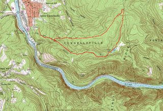
....a little more "wordy" than anticipated - but a highly recommended trip. Probably the best trail out there (and there's a lot) - 5 star for sure. Heres a map:


Again, mainline in red, alternates in blue with markers - each a rockclimbing crag. (*Note: I didn't include these trails - never got around to GPS mapping them, and am not positive, memory-wise, of their exact locations - more fun to explore that way, anyhow).

Here's some photos:

Rob Goodman, Ray Valco approaching the waterfall
along Limestone Run
Flat Rock Run
Split second before a face plant
Rob dropping over the rock ledge toward Rock Run -
the landing is the moss covered flat stone about 3 feet
below the front wheel - site of many good wipeouts 
Rob at the start of the hill climb out of Rock Run -
the exposed tree roots make it all the more difficult
Valco and the climb out of Rock Run
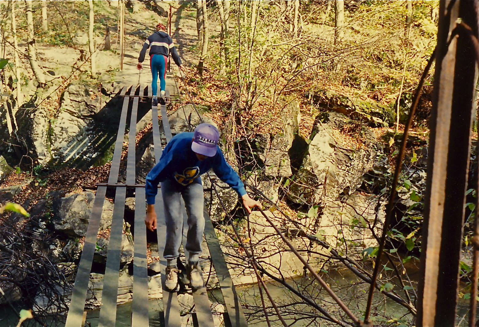
Rob and one of the several Dunbar Creek crossings
With Matt Burnsworth and Ray Valco - near the end
and cooling off - was a 95+ degree day  
All in all, a great ride. Lots of  short, steep and technical riding along the second half (past the second iron gate). The last fifth of a mile along Dunbar Creek is probably the limit of what can be ridden when talking rocks - nothing but creek boulders - been done though many times - with no suspension 'ta boot.

Sunday, January 6, 2013

The Big Loop (Mountain Biking Part 2)....

....start at the bottom of 'Casparis Hill' in South Connellsville, follow to 'Foleys Pond' - then north to 'Sandy Flats' - north/east to 'Sandy Flats Road' - east thru 'Hawkins Hollow' to Mt Tabor Road - south to 'Indian Creek' - follow Indian Creek (many swimming holes) to the Youghiogheny River - just west of the railroad trestle (bounce across the abandoned trestle for a bit of a thrill) -  wade the Yough River south to 'Camp Carmel' (< 2ft on the Ohiopyle River Gauge is best) - thru the camp (expect some hassle from the "camp counselors" - good people, none the less - if they're there - good place to refill water bottles, they have an outdoor wellhead with water faucet) - jump on the Yough River Trail (YRT) - east/south a few hundred feet to gate - right thru gate - follow long uphill - past Kraylick Rocks then flats to 'Iron Furnace' - stay right then north/west to long uphill to 'Elk Rock' - right at intersection then west to the second -  turn right to best single track downhill around (take a break to check out the Yough River overlook just before) - follow to the old 'timber mill' - stay right thru the woods - pick your way thru the single track - up hill then long downhill - when you run out of downhill, go left/south - follow to 'Cow Rock Road' ('frog pond' at intersection) - then northwest on 'Cow Rock Road' maybe 100ft - turn right (north) thru woods to steep technical downhill to YRT - then left/northwest back to ......

...e'nuff already!... about a 25 mile ride linking the east and west Yough River Gorge. Some serious elevation gain (for SWPA, maybe 1,800ft) capped by thee big hill climbs....here's a map.......


The red trail is 'main line'. Blue trails are links. Markers are just that - most are rock climbing locations.

Some photos (includes a few old prints) :  

A short, steep and technical hill climb
(Don't judge it from the photo)

(Matt)
Winter
(Howie)
Goodman
 At the time, other than a set of "wheels", didn't go much for slick or fancy outdoor gear or "threads". Wasn't a whole lot available, anyway. Let this guy get away with it, though - sort of like sporting an earring or tattoo back in the days. If you could backup your "game", no one messed with ya'.

The old "footbridge" crossing Indian Creek
Just below 'Terminator' rapid

(Matt, Rob)
Overlooking the 'Yough Gorge' from the west
The 'Three Sisters' boulders seen in the river bend
'Opperman Mine' is the cliffband in the upper right
Steep single track descending from the Overlook
Doyle Tarwater riding
(Again, don't let the picture fool ya')
Some great singletrack
(Doyle again)
The 'Yough River' crossing - before departing, check the
 'Ohiopyle' river gauge if not familiar with the flow - a little
difficult if the river is staging > 2ft

(Howie and Matt)
Rob atop one of the twin 'Pillars of
Hercules' at the 'Yough Gorge Crag' -
The 'Yough River' far below
Rob takin' a break at 'Kraylick Rocks'
Pretty much of everything on this ride and lots to view - giant boulders, cliff overlooks, waterfalls.... Watch out for timber rattlers and copperheads - and baby black bears during the season - ran into an angry mother once - and no matter what ya' think, mom isn't far away (and watching). Limited to the summer months because of the river crossing. Plenty of alternatives, regardless (see map). Would plan on at least a eight hour trip. You can leave a vehicle (or start from) the Yough River Trail parking in Connellsville or near the 'Wheeler Bottom' water plant as an alternative. Never tried to reverse the trail, and wouldn't want to attempt it - a few of the drops are steep and pretty technical and are not negotiable on return, unless on foot. Pays to be in top shape, as well. Took a small group of "experienced adventure racers" along once or twice and totally fried 'em (with lots of wipeouts on the slick, slippery rocks and fallen limbs - "f*k this" was a frequent comment). Personally haven't made the complete trip since probably 2000 (used to crank it 2-3 times a season), so no guarantees. I'm told that Indian Creek is now off limits with security patrols - someone is now running a campground up there - thats all I know of that. See the 'blue trail' on the map for a "bypass" (another steep downhill) that will take you to the lower section of the creek.

More to follow....